Blog Archive

Showing posts with label hiking. Show all posts

Thursday, June 4, 2026

Grand Staircase Escalante National Monument

My friend Jim and I visited the Grand Staircase Escalante National Monument in late May. It's a huge desert area between Bryce Canyon and Arches national parks. It's quite a diverse set of environments, from mountains to slot canyons. We spent about four days there and did a bit of driving and hiking. The great thing about this area is that it is full of world class scenery, yet very few people go there. So, unlike the national parks, you'll usually only see a few other people at any given time. And yet, Escalante has pretty good spots for breakfast, lunch, and dinner. 

The first day, we spent about a half hour wandering around at Hole in the Rocks, just west of the tiny town of Escalante, which served as our base. 


After walking around the Hole in the Rock rock formations, we headed over to the Spooky Gulch and Peekaboo Canyon trailhead. The approach hike was really a great hike in and of itself.


I loved the colors and wear patterns formed on the walls over thousands of years of periodic flash flooding. 


The light filtered down into the canyon and highlighted the many layers of sandstone deposits. These are on the vertical walls of the canyon, but they were the horizontal bottom of a sea tens of millions of years ago, then seismic forces crushed the entire area and upended the sea floor onto its side. Now the sedimentary stone is being worn away by floods over the intervening years.


This section is barely considered a slot canyon, as it's fairly wide in most places, so you don't have to squeeze sideways and take off your backpack. On the other hand, the very bottom of the canyon was not even as wide as my boot sole in some places. You can see how narrow it is at the bottom of this photo. Notice the sandy area that is the bottom. 


I had a great time doing the first part of the Spooky Gulch slot canyon hike, but I didn't take photos. My friend Jim waited for me to try a bit of it, then I bailed out after twenty minutes to rejoin him. It was really crazy to get started. You had to climb up a twelve-foot vertical rock face with only a couple of smooth dents in it for footholds. It was only because of my experience with indoor rock climbing with my brother that I had the skill and confidence to get started on it. Once I got started, the rest was not much easier. Almost every step was uphill, with four- or five-foot-high steps in many places. It was so much fun. After fifteen minutes it got so narrow you would have to turn sideways to get through, and it was following a serpentine shape - with ridiculously sharp turns every few feet. It looked amazing. 

The next day, we hiked to Lower Calf Creek Falls. In late May, the temperatures tend to be in the mid-80's, instead of 90's and above later in the summer. The hike is mostly flat and about three miles one way. 

This is the view of the canyon from the road that passes by above. The hike follows Lower Calf Creek, which waters all that greenery you can see along the bottom of the canyon in this photo. 


Once at the bottom of the canyon, you're looking up at impressive rock formations.


The walls of the canyons were hundreds of feet high, with amazing patterns of wear formed by a combination of rain, wind, bacterial, and geological forces, over thousands, even millions, of years. At times, it looked like an alien planet. 


I enjoy this image as if it were an abstract painting, with different styles and moods in different areas. Even though this is a stone cliff face hundreds of feet high, it is nearly perfectly smooth in some places, whereas other areas look scraped, gouged, flaked, and scalloped. At the same time, there is vertical striping, diagonal patches of ochre and orange, and textured horizontal layers crosscutting all of it. I imagine all the forces of nature as the artist composing the scene. A painting that took millions of years to create. 


Every good hike ends with a payoff view, and this was a good one. What an impressive waterfall, here in the middle of a desert, with a lovely pool that people were swimming in. Again, nature has "decorated" the orange and white stone with lime green, yellow, and blackish moss and lichen. The pattern of water on the rocks changed over time, depending on the flow of the water and wind. I specifically waited until the water had this beautiful cascading effect on the right side. At other times, there was no water at all on the right, so you had to notice this and take advantage of it.


On our final exploration of the area, we drove down East Burr Trail Road to Singing Canyon and beyond. The scenery along this section of road was spectacular, and yet there were only a few other people there. 

We learned that the different colors of stone making up the mountains and valleys of the area are the reason for the name Grand Staircase. Each layer is a different color, from the whites you see in the photo below, to the bright oranges in the subsequent photos, with a more tan sandy color for other areas. Each of these represents a deep layer formed over tens of millions of years and exposed by tectonic activity and wear and tear of the weather. In the photo below, I like all the etched patterns of layers of rock, which represent a story of various happenings in geologic time. Seas forming, earthquakes, floods, deposits, etc. 


This next two photos are from Singing Canyon. 


The funny thing is we didn't realize we were in Singing Canyon, but there was a guy there singing with his ukelele. The acoustics were fantastic. 


This entire canyon was just beautiful in all directions. This was just across from the Singing Canyon. 


This is another spot along the road with amazing patterns in the rock formed by so many different processes, from flaking of many layers of rock in the upper left, to microbes of different colors forming the vertical stripes following the flow of water running down the sheer rock face on the left, to fractures between distinct layers of rock in the lower portion of the photo. Astounding how there can be so many colors in a dry, stony, desert canyon. 


At the end of the canyon, we were treated to the view towards Capitol Reef National Park. 


I think there is much more to see in the area, so I'd like to go back someday soon. I recommend going before the secret is out! 

Wednesday, September 17, 2025

Trekking to the Ramoljoch Pass in the Austrian Alps

The last two days of our seven-day trek through the Otztal Valley in the Austrian Alps took us up over 4000 feet to the Ramoljoch pass, and then down the other side more than 5000 feet in a single day. It was my favorite part of the trip, as there are no ski resorts in this area, just glaciers and rivers and valleys above the tree line. Also, as you'll see in the photos, the morning of the second day was the climb to the saddle (AKA "joch"), where you get to the top and cross out of the Otztal Valley and into the other valley. 

Here we are after leaving the little village near the base of the valley. The hut is actually visible in this photo, but it's miles away. 

We passed a few grazing cows when we first started out. The jangling of their bells could be heard from a good distance. They were curious about us as we passed, probably hoping we had food for them.

As we climbed higher and higher on our side of the valley, the views of the other side got better. We could see a beautiful, braided river at the base of a side valley across from us. Also visible in the lower right of this photo are a couple of two-story buildings used for resupplying our hut by cable. There were cables stretched all the way from those buildings, across the valley, to our hut. There was a small aluminum box on the cable that could be used to send up food, toilet paper, and other essentials. 


There were no cows at the higher altitudes. We were heading to 10,000 feet (about 3000 meters) that day. Instead, we passed lots of sheep. They were also curious. Some even came over to see if we wanted to share our lunch with them. 


This was the view looking back towards where we started after a couple of hours. 

Here we have a good view of the Gurgl glacier. As with almost every glacier in the Alps, it's lost a large majority of its mass over the last fifty years. The bare rock marks where the ice used to reach. It's much smaller in terms of both height and length. 

After a few hours, we're getting closer to the hut, which is barely visible in the upper right corner of this photo. Unfortunately for us, it's closer, but still far above us. The trail rises gradually for most of the hike, but that changes at the very end. 

Here's how it looked as we got to the final approach to the hut. 


Luckily, this section of the trail was relatively short. 

Once we arrived at the hut, we sat out on the nice deck facing the glacier and the valley. It was only around 4 PM, and they weren't open yet. Luckily, they brought us food and drink out on the deck. It was fantastic weather, cool and pretty windy. It's funny everyone is looking at their phones here, as there was no signal, but one can try. Plus, they could have been reviewing all their photos of the day. 

Closer view of the glacier field across the valley. This is the Gurgl glacier. Notice the huts way up there, below the left ice field.

While we were waiting for dinner, I went back outside to look at the glacier. As it happened, a whole herd of sheep showed up to munch on the sparse grass around the hut. That poor grass has no chance to grow, as these guys eat every bit as soon as it pops up. It's hard enough with the cold weather and high altitude. I can't believe there's anything left alive once you add sheep. 


So, we spent the night in the Ramolhaus hut, in a tiny, six-bunk room, with sponge baths at the sinks in the (quite clean) bathrooms, and lots of snoring. Then it was time to do the last 500' of climbing to get over the Ramoljoch pass and start the 5000' descent to the town of Vent on the other side. 

When we woke up, we were in the clouds. We couldn't see anything but gray mist in all directions. After breakfast and packing up, we started to get glimpses of the mountains across the valley again. They would appear and disappear by the minute for the next couple of hours. 


Finally, it was clear enough to get started. We walked out the opposite side of the hut we had arrived from the night before, right onto the trail to Vent. As you can see from the photo, the clouds were filtering through as we walked. It was very slippery crossing the packed snow, but we managed. 

Then we reached the really exciting part - the via ferrata - where they've installed metal steps, with cables to hold onto, for the 500' ascent to the saddle.


You can tell how steep it is from the way the people only a few steps ahead are almost directly above us. 


I absolutely loved this section and wished it was even longer!


Since before the trip began, I'd been worrying that the heights, exposure, difficulty, and technical nature of this section would cause problems for our group. Our guide company rated this section as "Extreme." Fortunately, none of it slowed down the group at all. We went right up this section without a complaint or a rest. 


Here's how it looked facing back toward the way we came as we got near the top. As you can see, the clouds still hadn't cleared out by the time we reached to top. They were still filling up the Otztal Valley that we had come from. 


Finally, we reached the top, which was around 10500'. From up here, we could see into the other valley, which had its own glaciers. I loved how the clouds were below us, and hugging the mountains on the far side of the next valley.  We were curious why the glacier clearly had two different colors, and all these black lines of sediment.


The rest of the day, we would be hiking all the way down, even lower than the lowest part of that green area, a descent of over 5000'. Long day, but we brought plenty of food and water and took a few breaks to enjoy the views and listen to the glacial river flowing beside us. We were so lucky with the weather on this day too, as it had been raining every day earlier in the trip. 


Sunday, January 9, 2022

Yellowstone National Park Mammoth Springs, Grizzlies, and More

I'd heard of Mammoth Springs many times over the years, and seen some kind of boring photos, so I wasn't that excited about visiting, but I ended up being really impressed.  As we did every morning, we were out of bed by 6:30 (which was 8:30 Eastern time), and ended up being the first among a few to arrive.  It was the perfect time of day, as the springs face east, and the sun was just coming up. 

In this section, a cascade of pools formed one after the other. The water trickles all the way down from one pool to another, depositing tiny amounts of minerals.  This has been going on since before the Egyptians were building pyramids. 

Mammoth Hot Springs in Yellowstone National Park

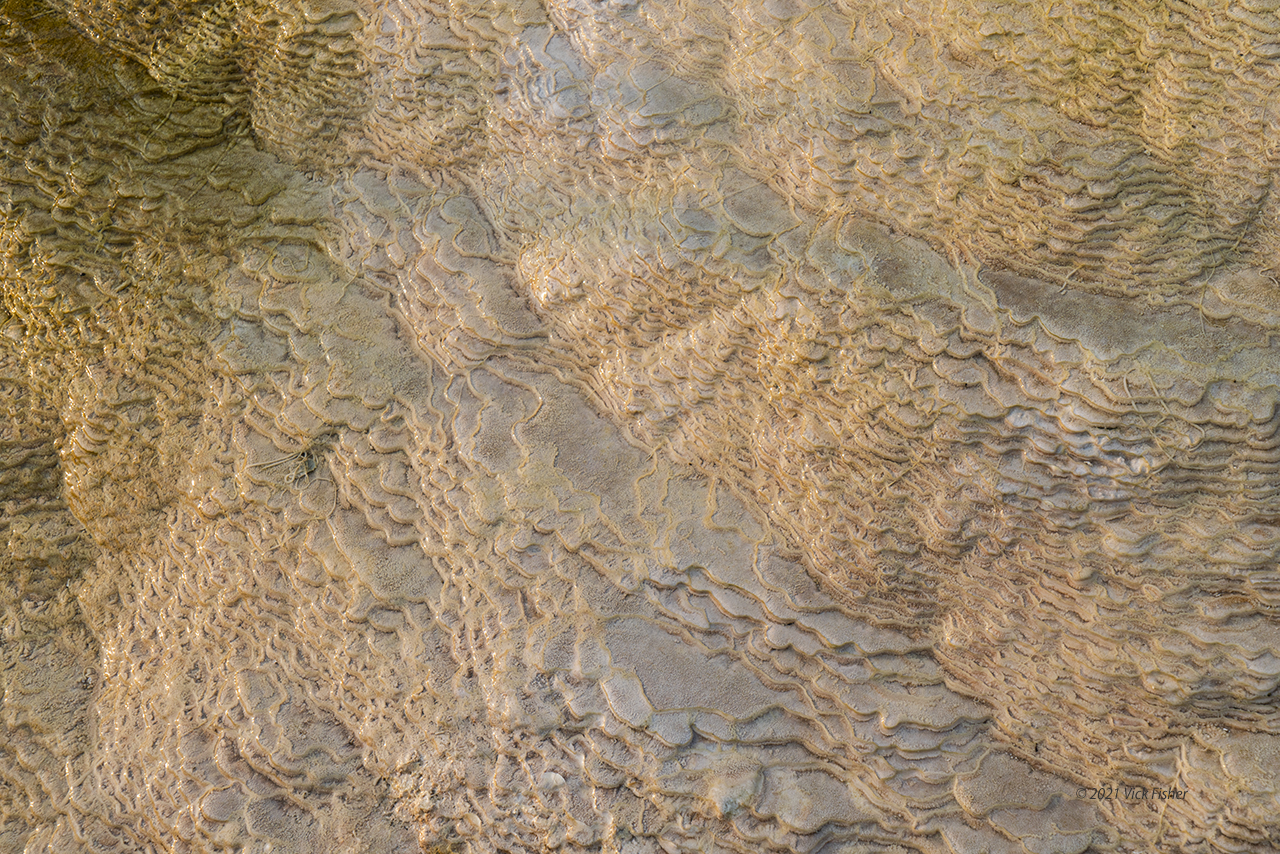
Over thousands of years, the mineral-laden water has formed intricate patterns in stone.  It's hard to comprehend how many layers there are.  This shows one small section with around eighty layers.  

Mammoth Hot Springs in Yellowstone National Park

You can see even more, and more colorful, layers in this one.

Mammoth Hot Springs in Yellowstone National Park

The best section was the last we reached along the many wooden pathways among the springs. This is the largest vertical face of any springs we saw.  It was still early in the morning and cold, so there was a lot of steam.  

Mammoth Hot Springs in Yellowstone National Park

Another from the same area, at the top of the big face of the springs.  This is the source for the water that trickles down the biggest face of Mammoth Springs.

Mammoth Hot Springs in Yellowstone National Park

Here is the largest face of the springs. The whole hill we've been walking on is the accumulation of thousands (millions?) of years of trace amounts of sediments in the spring water hardening into these shapes as it flows up from below, then downhill.  A little like an extreme case of hard water in your home plumbing. I love the pure white, which is all stone - probably calcium.

Mammoth Hot Springs in Yellowstone National Park

This is a closeup view of the same face. I love how the rock has formed into intricate diamond crisscross patterns.  The pure white is amazing. 

Mammoth Hot Springs in Yellowstone National Park

Here the cold air hits the hot water of the springs.

Mammoth Hot Springs in Yellowstone National Park

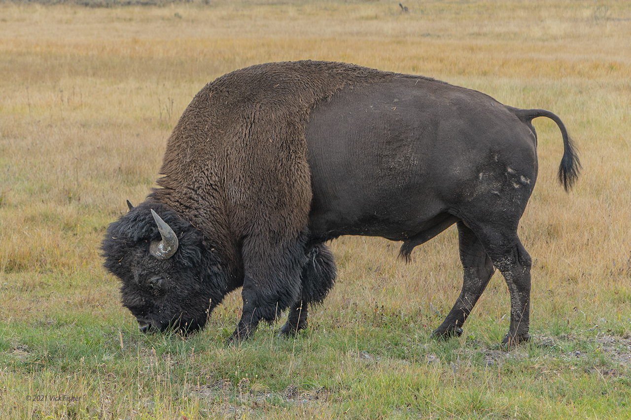
Wildlife seems to be doing really well in Yellowstone National Park.  Of all the animals we saw, the bison ignored people more than any other.  They just didn't care.  You've probably seen those films and photos where the bison just walk across the road right in front of cars.  That did happen to us - a big traffic jam just because there was a herd split across both sides of the road, and every once in a while one or a few would decide they wanted to cross.  

We got closer than the recommended distance on foot a couple of times.  I swear it wasn't on purpose!  They just pop up out of the woods, and there you are, too close together.  This one was taken leaning out of the car window.   

Grazing bison in Yellowstone National Park

This time, we were on foot and ended up closer than we should have been.  We felt a little safer being up on a wooden walkway a foot off of the ground, but probably shouldn't have. That railing ends right in front of me, so there was nothing between us and him except one step up. We waited a few minutes for him to move a little further away, but instead he just came up until he was practically touching the walkway.  So, we ended up turning around.  Second time on the trip when we had to detour due to wildlife. 

Close to a bison in Yellowstone National Park

We saw black bears a few times on the trip.  Twice, there were two black bears together in a single tree.  The first time, the tree was right beside the road, and the rangers had set up orange cones directing all traffic into the other lane and were standing along the road every fifty feet waving people along telling us not to stop.  So, no photos that time.  The second, they were pretty far off the road, so we were able to stop and watch for a while.  People said the mother likes to do this so any predators have to go through her to get to her cub.  

Black bear mother and cub resting in a tree at Yellowstone National Park

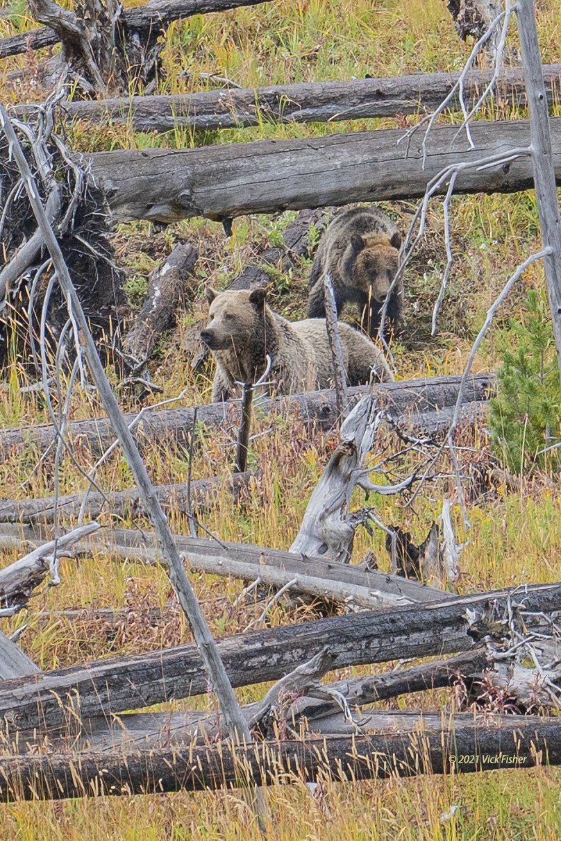
Finally, near the end of the trip, we got to see grizzlies near the lake.  Grizzlies are also known as brown bears.  That's actually a more correct name for them, apparently.  But grizzly sounds so much better!  These were pretty far from the road, so we were always at a safe distance.  And there were quite a few people stopped to watch.  Three of them had tripods set up with very long lenses.  If I lived in a place where wildlife was that plentiful, I'd definitely get one of those lenses!  This first photo shows the mom and her cub together. 

Grizzly bear mother and cub foraging in Yellowstone forest

The cub.

Grizzly bear cub foraging in Yellowstone forest

The cub again.  

Grizzly bear cub foraging in Yellowstone forest

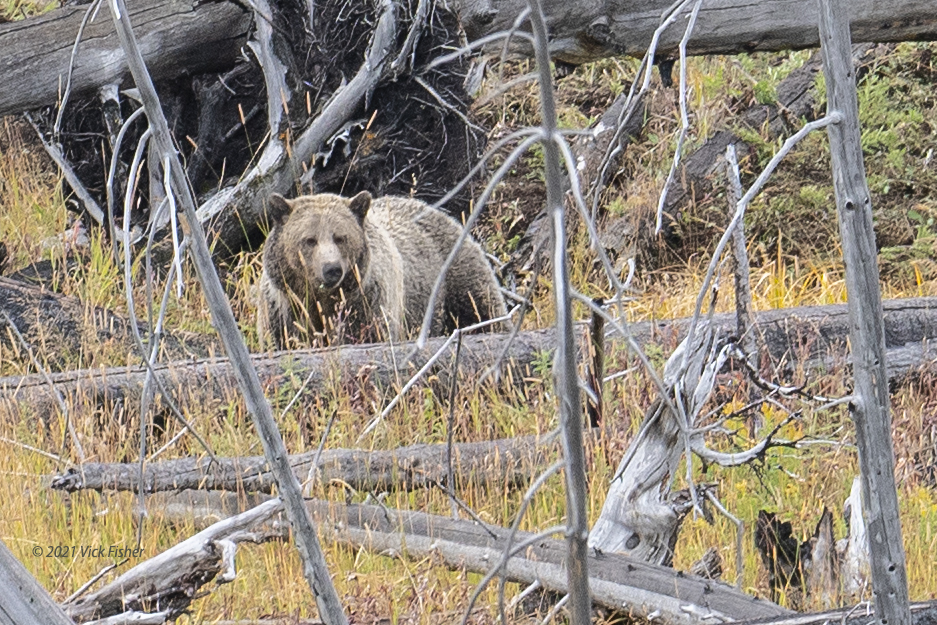
I think this is the mom.  

Grizzly bear mother in forest

That was pretty exciting.  You never know if you'll get to see a grizzly, so we felt really lucky.  

After four photo essays, we finally reached the end of this trip.  Thanks for reading to the end.  Hope you enjoyed!  

The previous three posts cover the beautiful and amazing waterfalls, canyons, springs, geysers, and very close up moose we saw on the trip. Here are the links to those posts:

Grand Teton National Park Mountain Lakes, Bears, and Moose

Yellowstone Geysers and Grand Canyon

Yellowstone Springs and Waterfalls


Popular Posts